High-Resolution Bushfire Risk Analysis in a Wet Fire Season
A wet year leaves patchy burns. The unburnt gaps are tomorrow's fuel — and the question is which of them matter.

Matthew Robards
A wet year brings growth. Across northern Australia the 2025 season has been defined by significant rainfall, leading to abundant, dense vegetation. While this green landscape is welcome, it presents a heightened challenge for fire managers. How do you conduct mitigation burns effectively when the landscape is holding so much moisture?
In our last post we showcased the ten-metre precision of FiSci’s fire scar detection. Here we explore why that matters more than ever in a wet year, where understanding the mosaic within a burn is the key to preventing future disaster. Early dry season burns are designed to reduce fuel, but in a saturated landscape they are rarely uniform — and they leave behind a crucial, often overlooked legacy: the gaps.
The hazard hiding in plain sight
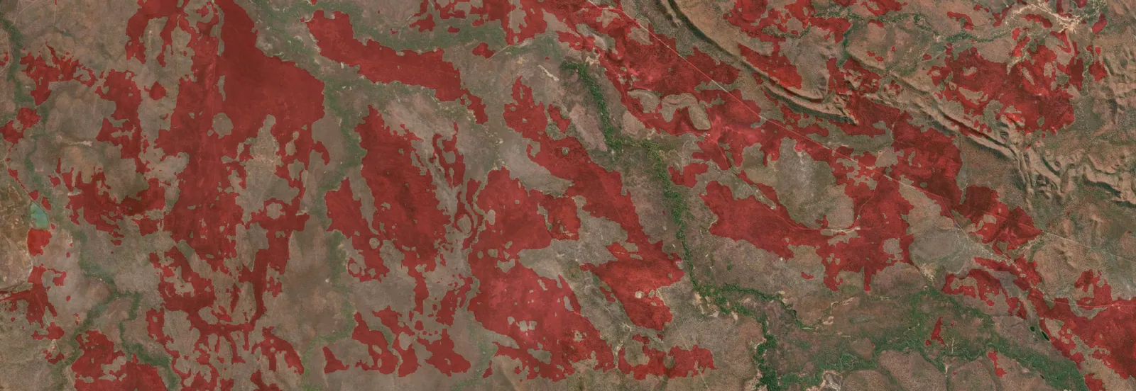
Look at a fire scar map generated by FiSci Detect from prescribed burns conducted on a Northern Territory property over May and June 2025. The challenge of an exceptionally wet year is immediately apparent: the burn leaves a highly fragmented landscape. The red areas show what has burned, but the real story is in the gaps — the vast unburnt areas left behind.
This patchiness isn’t random. It’s a direct result of landscape conditions at the time of the burn.
Following the moisture
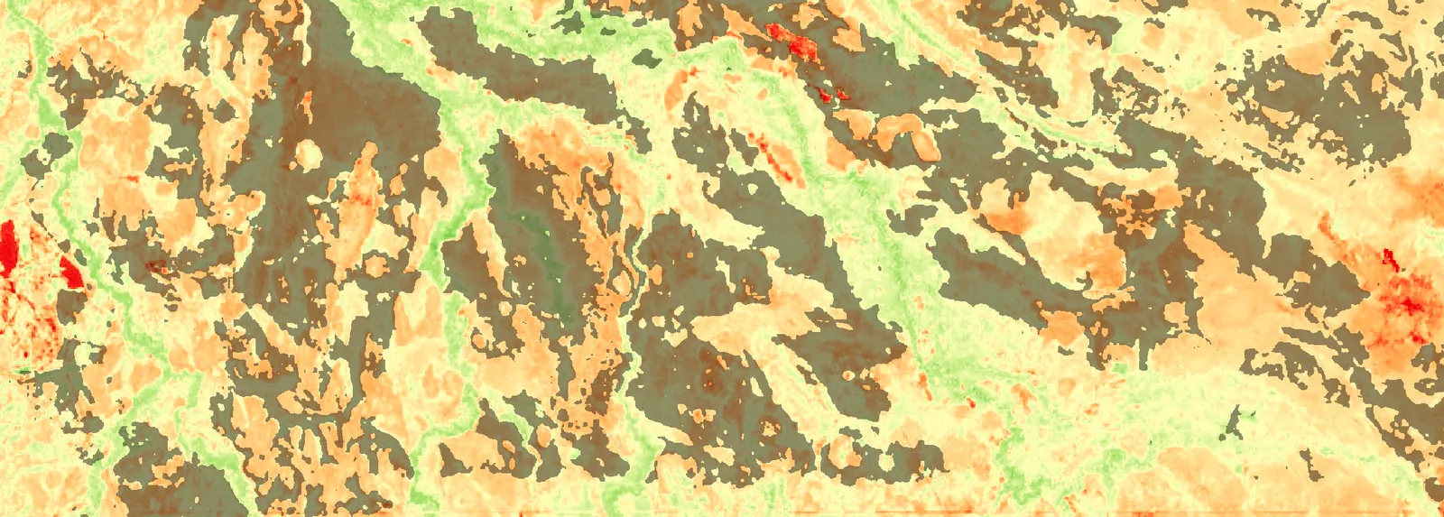
The primary factor determining whether vegetation will burn is its moisture content, and in a wet year that becomes paramount. We use the Global Vegetation Moisture Index (GVMI), a satellite-derived measure, to map water content in vegetation before a burn.
The GVMI map from early May 2025 is striking; the extensive bright green areas reveal how much water the landscape was holding. Overlay the subsequent fire scars and the link is undeniable: the fires simply burned around the moisture-saturated parts of the landscape.
Today’s firebreak is tomorrow’s fuel
In the early dry season these moist, unburnt patches act as natural firebreaks. But as the season progresses they cure and dry out. After a wet year the fuel load in these gaps can be much higher than average. They become continuous, heavily-fuelled corridors. An ignition in the late dry season can exploit them, letting a high-intensity wildfire move through now-cured, dense grass and bypass the earlier mitigation entirely.
Identifying the gaps is the first step. The critical next question is: which gaps matter most?
From detection to decision
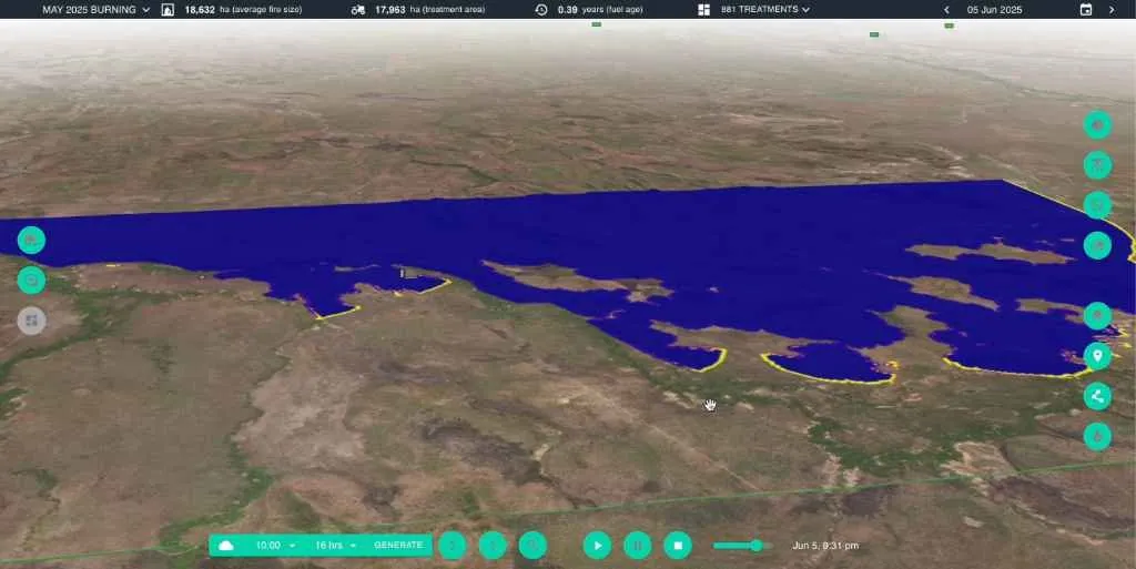
This is where the workflow comes full circle. Once Detect has identified the precise fire scars, we import that data directly into Mitigate. There we can simulate the behaviour of potential late-season fires under more extreme conditions.
The platform uses the exact boundaries of the unburnt gaps to model how a future fire might spread, effectively testing the integrity of the initial burn. That moves beyond identifying gaps to actively prioritising them — showing land managers which unburnt areas pose the most significant risk of allowing a large fire to escape, so they can focus resources and close the most critical gaps before they become a threat.
It’s this end-to-end path, from high-resolution detection to predictive simulation, that gives the clarity needed for proactive savanna fire management — especially in a wet year.